
Season 2007
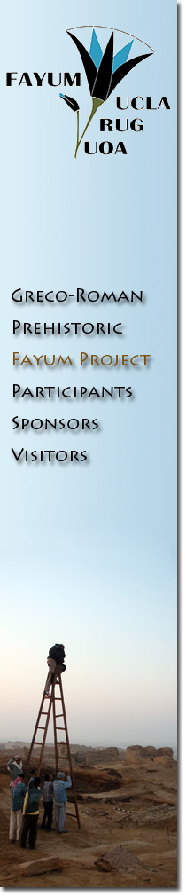
This year's campaign started with an enormous loss. In September 2007, the project found that the western part of the Upper K Pits, that contained the best preserved Neolithic granary and in which we worked in 2004 and 2005, had been completely destroyed by an enormous trench, dug by machines. The robbers even dug the last meters by hand, not finding any 'treasures' obviously.
Deep illegal excavation in the Western Upper K Pits area. The scraping traces along the walls show the use of heavy mining equipment.
Survey and excavation on north shore Lake Qarun
Work continued in Kom K. As outlined in the 2006 report, and the 2007 interim report, this area is of world importance. To have a Neolithic site with an intact stratigraphy is almost unheard of in Egypt, where most prehistoric sites are deflated and only have surface material.
The results of our excavations at Kom K were extremely important and were announced to the press by Dr. Zahi Hawass and Mr. Farouk Hosni in early 2008. The discovery of domesticated wheat and barley in a settlement context enables us to say with certainty that the Neolithic inhabitants of the Fayum were growing, storing and consuming grain.
In addition many carbonized sheep and goat droppings were found in the hearths of Kom K, indicating that dung was used as a fuel. From the zooarchaeological finds it is clear that domesticated sheep, goat and pig were consumed, as well as a wide range of large and smaller fish from the lake.
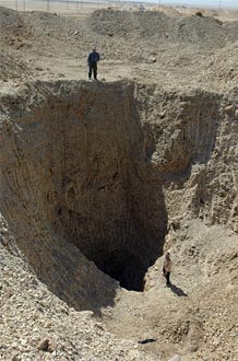
Google map showing the relative location of Kom K and the Upper K Pits
The most promising discovery was that there is at least 60 cm of undisturbed stratified Neolithic deposit at the center of the mound. This is the area that presumably was completely excavated by Caton-Thompson and Gardner in 1927. We hypothesize that Caton-Thompson presumed the layering of hearth upon hearth was exhausted when she reached a 25 cm deep sand layer. Subsequent plowing and wind erosion removed most of the layer excavated in the 1920s, but the sand layer remained intact and we found several hearths in these deeper Neolithic layers. Continuation of the work in 2008 hopefully will give the Neolithic settlement of Kom K considerable time depth.
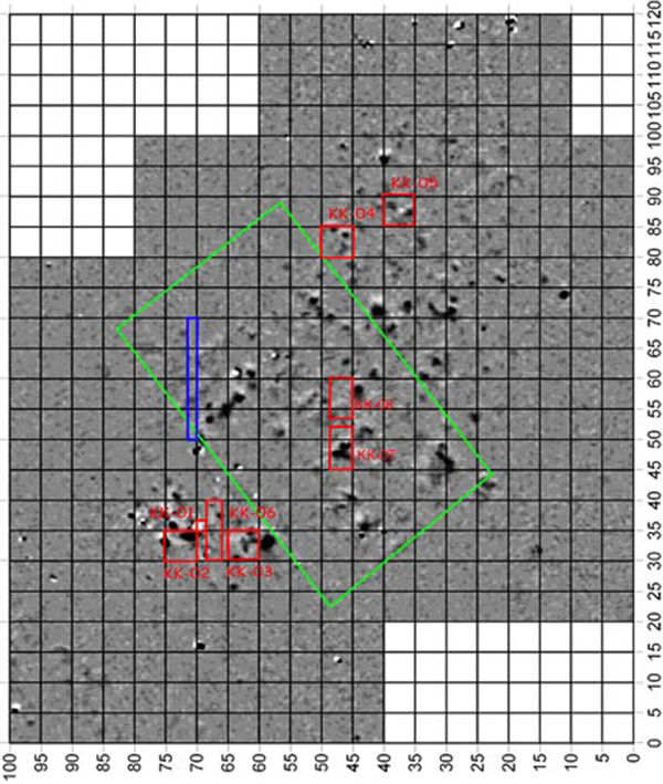
Magnetic map of Kom K
Site management in Karanis (Kom Aushim)
A mud brick research project was started in order to understand the composition of the mud brick in different parts of the site. This research is used both to understand the architectural history, and prepare for conservation of the mud brick. A topographical map was made of the area that was excavated by Cairo University in the 1970's.
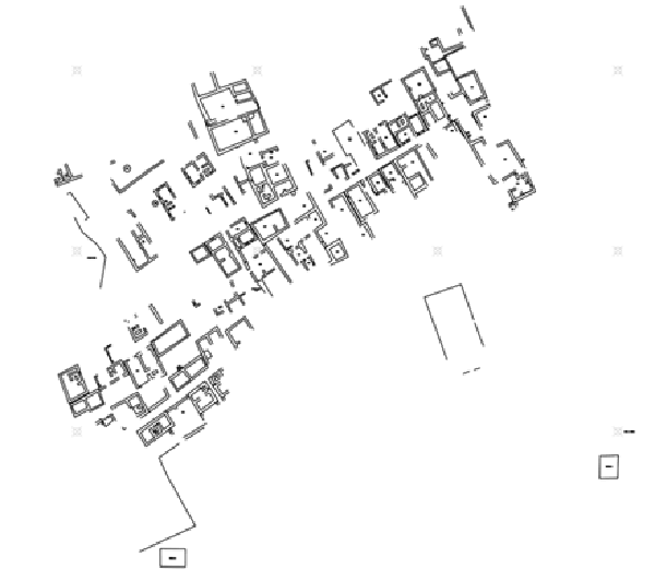
2007 topographic survey of Karanis by Hans Barnard and Gregory Marouard
Canal Survey
Caton Thompson and Gardner in the 1920s identified nine canals, which they considered to be part of the Ptolemaic infrastructure to expand the cultivable area. Our project made an effort to locate these, and do some precise elevation measurements in order to better understand the watering system.
Fifteen exploratory trenches were excavated in the canal system around the north and north-east of lake Qarun. All canals known from the 1920s were relocated, but some have been damaged or destroyed by modern construction, quarrying and agricultural activity. One new canal was identified. The canals that could be dated through associated pottery appeared to be early Roman, rather than Ptolemaic.
See also: Trenches and supervisors in 2007.